Why Do We Get Floods?


During the last few years, Queensland has had some very bad floods. Unfortunately, the reason for these floods is often not very clear. There are various theories and assumptions behind them. These include a lack of proper land use planning, a Recurrence Interval (RI), and a legacy of past floods.
Table of Contents
EMSR567: Queensland floods
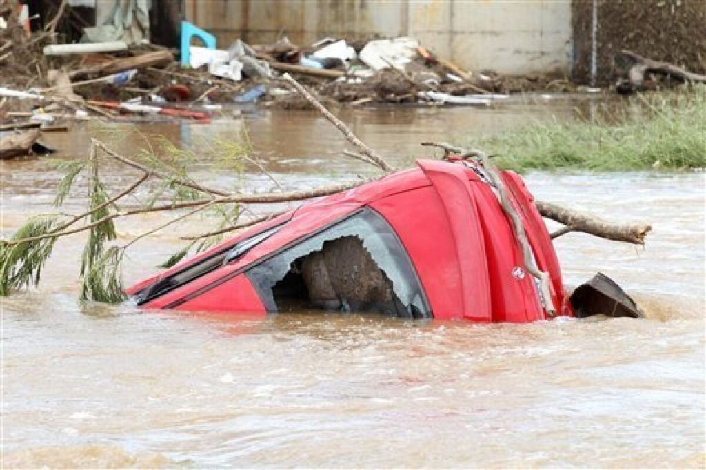
Hundreds of Queensland homes and businesses were affected by floods in late February. Some areas were flooded to the point that roads were cut off and schools were closed. The town of Gympie was hit the hardest.
The floods were the biggest natural disaster to hit Queensland in decades. The flooded areas left behind massive amounts of mud and debris. The area also suffered from several mine closures that disrupted coal transport.
The National Bureau of Meteorology has issued flood warnings for several regions in Queensland. They have also warned that further heavy rain on Friday could lead to life-threatening flash floods. The flooding has left hundreds of homes and businesses without power.
Top-down rain
Thousands of homes and businesses were submerged in Brisbane and along the Queensland coast during flooding in 2011. A series of intense rain events and the subsequent storm water were responsible for at least 33 deaths.
Major flood warnings were issued for several rivers including the Bremer, Mary and Mooloolah rivers, and the Stanley and Lockyer creeks. Major flood levels were also recorded in the Laidley, Tenthill and Warrill creek systems. The Wivenhoe Dam is set to release late on Friday night, and is expected to flood downstream areas.
The rain was so intense that the Brisbane river peaked at 3.7m at 9am on Monday, above the previous flood peak of 3.2m in 2011. Brisbane Lord Mayor Adrian Schrinner warned of a unique weather event. He said that this could be the worst flooding in a decade.
Recurrence interval (RI)
Using statistical techniques, a study has estimated the chances of various types of floods occurring. These estimates are based on the concept of a recurrence interval. Recurrence intervals are defined as the average number of years between events of a particular magnitude. Generally, the more years of historical data that are available, the better the estimation.
The statistics used in this study include annual peak discharge, stage (elevation of the water surface), and the recurrence interval. These are plotted against a Y-axis and are summarized in Figure 2. This analysis is the most appropriate for estimating the chance of different sized floods.
There are many variables that influence flood risk, including climate change, water storage levels, and dam capacity. These can complicate estimates of flood risk changes.
Unanticipated flooding in Brisbane River tributary catchments
During 2011 Brisbane was struck by unanticipated flooding in Brisbane River tributary catchments. Cyclones and heavy rain over many months caused a flood event that lasted for more than a week. The floods destroyed thousands of homes and left hundreds of people without power. It also left up to a third of Brisbane’s population homeless.
The Brisbane River floodplain covers an area of 15,000 square kilometres. Dams are only able to capture water from the northern part of the Brisbane River catchment. The dams are not able to stop the flow of water from other tributary catchments.
The third cyclone hit Brisbane on 19 February, largely due to the upper reaches of the Brisbane River. It caused 35 deaths and left up to one third of Brisbane’s population homeless.
Legacy of poor land-use planning
During the Brisbane floods in 2011, the legacy of poor land-use planning was exposed. Homes were built in flood prone areas. As a result, 198 buildings in two local council wards in South Brisbane were destroyed.
Many properties were left without electricity and gas, and the Port of Brisbane was closed due to a threatened water supply. Residents in lower income neighborhoods were left without resources to respond to the storms.
There were also reports of homelessness, destitution and unemployment. Journalists vividly documented the devastation. The flooding caused a miasma of debris and dead animals.
Brisbane is built on a flood plain, and the community understands that water security is linked to liveability and flood resilience. However, the city has long had challenges with urban water quality.
Blackouts and NBN outages
Thousands of households and businesses are suffering from blackouts and NBN outages in Queensland. The network was impacted by floods that damaged telecommunication infrastructure in towns north and west of Brisbane. While the floods have subsided, many homes and businesses remain without power.
NBN Co is deploying generators to support connectivity in flood-hit areas. A number of sites have been restored in the last two days.
NBN is working with emergency authorities to restore services. Some affected areas include Brunswick Heads, Kingscliff, Logan and Tweed Heads. However, a number of sites remain out of service, including the Woodburn fibre access node.
NBN Co has been conducting meetings with local government authorities and emergency services. It’s also set up satellite-based Wi-Fi hotspots in northern NSW to provide connectivity to homes in the affected areas.


